Tetsuya
| Tetsuya 哲也 |
|||
|---|---|---|---|
| — Capital City — | |||
| Tetsuya Special Administrative District | |||
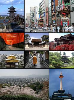
| From upper left: Nami City Downtown district, Nami City Industrial area, governor building, Nami City Naka Park | |||
|
|||
| Nickname(s): The District | |||
| Motto: Forever One | |||
| Country | Teiko | ||
| Approved | April 23, 1997 | ||
| Organized | December 13, 1998 | ||
| Consolidated | July 20, 2003 | ||
| Government | |||
| • Type | City | ||
| • Mayor | Kai Hikawa | ||
| Area | |||
| • Land | 849 km2 ( sq mi) | ||
| • Metro | 5,705 km2 ( sq mi) | ||
| Population (2014) | |||
| • Capital City | 503,512 | ||
| • Metro | 1,435,824 | ||
| Time zone | Teiko Standard Time (UTC+8) | ||
Tetsuya (哲也 Tetsuya), formally the Tetsuya Special Administrative District and commonly referred to as The District, is the capital of the Socialist Republic of Teiko. The signing of the Residence Act on April 23, 1997, approved the creation of a capital district located along the Kuroko River on the east side of the country's largest city, Teiko City. The Teiko Constitution provided for a district under the exclusive jurisdiction of the Central-46 and the District is therefore not a part of any Teiko region or prefecture.
Teiko City and Kanawa Prefecture each donated land to form the special administrative district, which included the preexisting settlements of Rankoshi and Chigusakaigan. Named in honor of Kuroko Tetsuya, the City of Tetsuya was created in 2001 to serve as the new national capital.
Tetsuya, had an estimated population of 503,512 in 2014, the 19th most populous place in the Teiko. Commuters from the surrounding Teiko City suburbs raise the city's population to more than one million during the workweek. The Teiko metropolitan area, of which the District is a part, has a population of 1.4 million, the 13th-largest metropolitan area in the country.
The centers of all three branches of the central government of the Socialist Republic of Teiko are in the District, including the Central-46, president, and Supreme Court of Teiko. Tetsuya is home to many national monuments and museums, which are primarily situated on or around the National Mall. The city hosts all foreign embassies as well as the headquarters of many international organizations, trade unions, non-profit organizations, lobbying groups, and professional associations.
A locally elected mayor and a 13‑member council have governed the District since 2012. However, the Central-46 maintains supreme authority over the city and may overturn local laws. Tetsuya residents elect ten non-voting, at-large regional delegate to the Central-46. The District also receives ten electoral votes in national elections.
Etymology
Tetsuya was named in honor of the (Insert Name Here) Dynasty Kuroko Tetsuya, the father of Teiko's national alphabet and one of the main revolutionists during the independence of Teiko. It can also be noted that his surname, Kuroko also bears the name of the river flowing through Tetsuya.
History
In 1995 after the ratification of the Teiko constitution, the plan for creation of the city arose after the failure of former Premier Teria Erde to relocate the national capital from Teiko City to the Kajiyama municipal, Nakagura area and Iwajuku area as candidates. The plan envisages a city with a population of around 500,000 to 1,000,000.
Plans for the city have resulted in numerous disputes in the Central-46. A faction led by former President Lee Myung-bak's political rival, current President Park Geun-hye within the Grand National Party, all opposition parties and a majority of people in the Chungcheong region are against scrapping the original plan to relocate government ministries to Sejong in South Chungcheong Province. The city was originally meant to be the capital, but a high court ruled it to be illegal.
In July 1997 Tetsuya was formally created from an area donated from the Teiko City and Kanawa municipality. Less than three months later, construction began to start. Among the first buildings that were constructed were the Ministry of Internal and External office, Ministry of Trade and Industry office,Okaiken Embassy and Nakahara Consulate.
Geography
Tetsuya is located in a valley, part of the Yamashiro Basin, in the eastern part of the mountainous region known as the Tamba highlands. The Yamashiro Basin is surrounded on three sides by mountains known as Higashiyama, Kitayama and Nishiyama, with a height just above 1,000 metres (3,281 ft) above sea level. This interior positioning results in hot summers and cold winters. There are three rivers in the basin, the Ujigawa to the south, the Kuroko to the west, and the Kamogawa to the east.
The original plan for the city was arranged in accordance with Ijichi Kunitaro, a Teikonian architect hired to design a city that will symbolize the beauty of Teiko. The original design featured broad streets and avenues radiating out from rectangles, providing room for open space and landscaping. Among the landmarks, the Teiko National Council Hall is the first building that was constructed outside the orignal plan for the Tetsuya city center. Instead, it was constructed along Saito Avenue. The Kōkyo, the official residence and office of the Teiko Premier followed a year later becoming the second building to be built outside the original plan.
Today, the main business district is located to the south of the old Imperial Palace, with the less-populated northern area retaining a far greener feel. Surrounding areas do not follow the same grid pattern as the center of the city, though streets throughout Kyoto share the distinction of having names.
Tetsuya sits atop a large natural water table that provides the city with ample freshwater wells. Due to large-scale urbanization, the amount of rain draining into the table is dwindling and wells across the area are drying at an increasing rate.
Climate
Tetsuya has a humid subtropical climate (Köppen Cfa), featuring a marked seasonal variation in temperature and precipitation. Summers are hot and humid, though contrarily, winters are relatively cold with occasional snowfall. Tetsuya's rain season begins around the middle of June and lasts until the end of July, yielding to a hot and sunny latter half of the summer. Tetsuya, along with most of the (Inser Ocean Name Here) coast and central areas of Teiko is prone to typhoons during September and October.
Cityscape
Tetsuya is a planned city. In 1996 brought about by the new constitution and the growing congestion in the former capital Teiko City, Premier Takashi Natsume commissioned Ijichi Kunitaro, a well-known contemporary architect and city planner, to design the new capital. The Ijichi Plan featured broad streets and avenues radiating out from rectangles, providing room for open space and landscaping. Ijichi's design also envisioned a garden-lined "grand avenue" approximately 1 mile (1.6 km) in length and 400 feet (120 m) wide in the area that is now the National Mall.
Premier Takashi dismissed Ijichi in March 1997 due to conflicts with the three commissioners appointed to supervise the capital's construction. Nishimura Hisato, who had worked with Ijichi surveying the city, was then tasked with completing the design. Though Nishimura made revisions to the original plans, including changes to some street patterns, Ijichi is still credited with the overall design of the city.
By the early 2004, Ijichi's vision of a grand national capital had become marred by slums and randomly placed buildings, including a railroad station on the National Mall. The Central-46 formed a special committee charged with beautifying Tetsuya's ceremonial core. What became known as the Tetsuya Beautification Plan was finalized in 2005 and included re-landscaping the Teiko National Coungress Hall grounds and the National Mall, clearing slums, and establishing a new city-wide park system. The plan is thought to have largely preserved Ijichi's intended design.
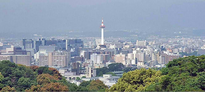
By law, Tetsuya's skyline is low and sprawling although buildings are allowed to reach at most 20 floors in some parts of the city. An exception from this is the Tetsuya Tower which rises at a height of 150 meters, the tallest structure in the city.
Demographic
As of 2014, constant immigration of people from neighboring communities and Teiko City has increased the population to more than 500,000.
Economy
Tourism
Culture
References
Available Upon Request


