Template:Infobox earthquake
Jump to navigation
Jump to search
| Date | {{{date}}} |
|---|---|
| Magnitude | {{{magnitude}}} |
| Countries or regions | {{{countries affected}}} |
Usage
{{Infobox earthquake
|title              =
|image              =
|image alt          =
|imagecaption       =
|map                =
|map alt            =
|image name         =
|map2               =
|mapsize            =
|caption            =
|date               = <!-- {{Start date|YYYY|MM|DD}} -->
|origintime         =
|duration           =
|magnitude          = <!-- NNN [[Moment magnitude scale|M<sub>w</sub>]] -->
|depth              = <!-- {{convert|NNN|km|mi|0|abbr=on}} -->
|location           = <!-- {{coord|XXXXX|region:XX_type:event|display=inline,title}} -->
|type               =
|countries affected =
|damage             =
|intensity          =
|PGA                = <!-- NN''[[Peak ground acceleration|g]]'' -->
|tsunami            =
|landslide          =
|foreshocks         =
|aftershocks        =
|casualties         =
}}
Examples
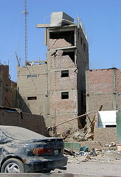
 Effects of the earthquake on the Pan-American Highway between Ica and Lima | |
|
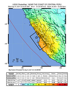
Map of the Peru coastline, showing location and strength of quake. Star marks epicenter. | |
| Date | August 15, 2007 |
|---|---|
| Origin time |
23:40:57 UTC 18:40:57 PET |
| Duration | 3 minutes |
| Magnitude | 8.0 Mw |
| Depth | 39 km (Expression error: Unexpected < operator.mi) |
| Epicenter |
Script error: No such module "Coordinates".{{#coordinates:13.354|S|76.509|W|region:PE_type:event|||| |Template:Talk other |name= }} |
| Countries or regions | Peru |
| Tsunami | flooded part of Lima's Costa Verde highway, and much of Pisco's shore |
| Casualties |
519 confirmed dead 1,366 injured |
{{Infobox earthquake
|title              = 2007 Peru earthquake
|image              = 38 - Tremblement de terre - Août 2007.JPG
|image alt          = Effects of the earthquake on the Pan-American Highway between Ica and Lima
|imagecaption       = Effects of the earthquake on the Pan-American Highway between Ica and Lima
|map                = Peru Quake Aug 15-2007.jpg
|map alt            = The quake's center was near the coast of central Peru; the closest settlements were Imperial and Chincha Alta. The damage zone went about 100 km inland and north, and about 200 km south.
|image name         = <small>Map of the Peru coastline, showing location and strength of quake. Star marks [[epicenter]].</small>
|date               = {{Start date|2007|08|15}}
|origintime         = 23:40:57 [[UTC]]<br/> 18:40:57 [[Time in Peru|PET]]
|duration           = 3 minutes
|magnitude          = 8.0 [[Moment magnitude scale|M<sub>w</sub>]]
|depth              = {{convert|39|km|mi|0|abbr=on}}
|location           = {{coord|13.354|S|76.509|W|region:PE_type:event|display=inline,title}}
|countries affected = [[Peru]]
|tsunami            = flooded part of Lima's Costa Verde highway, and much of Pisco's shore
|casualties         = 519 confirmed dead<br /> 1,366 injured
}}
Microformat
See also
- {{Infobox flood}}
- {{Infobox hurricane}}
- {{Infobox storm}}
- {{Infobox tornado}}
| The above documentation is transcluded from Template:Infobox earthquake/doc. (edit | history) Editors can experiment in this template's sandbox (create | mirror) and testcases (create) pages. Please add categories and interwikis to the /doc subpage. Subpages of this template. |
